Carp Fishing - Doing Your Venue Homework
Very few carp anglers seem to do their own homework these days. Just recently there have been a few debates about some north west carp anglers wanting everything handed to them on a plate. I’ve commented before on how easy it is to just log onto a carp fishing forum and ask what water, what bait and where do I cast?. How any carp angler can pat himself on the back and be pleased at catching a fish when he owes most of it to somebody else’s hard work is beyond me. It does seem that carp fishing is full of the kind of people who’s attitude is ‘I want it, I want it now and I don’t care how I get it’. Carp forums in particular seem to attract these type of anglers in numbers. Working things out for yourself and catching carp on your own terms is so much more rewarding than stooping to begging for information on a carp forum. Imagine the scenario, you’ve just joined a carp water, you know its got some big carp in and catching them is your personal goal, something you are striving to achieve. So why take away some of the merit of capturing those fish by asking other anglers where the best hot spots are?. Learning a new water is the best part of carp fishing, it keeps you thinking and learning.
When you watch the carp, learn about them and start getting amongst them on your own, you get more of a sense of achievement than if its handed to you on a plate. But how do you actually go about doing your homework on a venue and getting amongst the carp your chosen water contains?. What follows are some of the things I do, I won’t insult the readers intelligence by explaining how to use a marker float, there are plenty of carp magazines around that cater for that, what follows is how I go about doing things myself.
Personally, I like modern technology and I find the internet extremely helpful when it comes to gaining information about a carp venue. The very first thing I need to know is how to get to my chosen water. That might sound a bit obvious but I’m based in Wirral and I fish all over Cheshire and Shropshire. I quite often find myself getting lost when looking for a new lake so the first thing I do is plot a course to the lake with my Sat Nav
With directions to the lake sorted out the next step is to find out a bit of basic information about a chosen water, obviously the forum search facility may reveal some old threads but the information in them may or may not be useful. If I’ve chosen to fish a venue, I’ve done so either because I’ve already heard on the bank that it contains the size of carp I’m interested in, or it’s a bit of an unknown that might be work a look. The basic information I’m after is the size of the lake, which way is North?, how many swims are there?, is there any weed, lily pads or other visible features? and at what kind of range are they from the bank?.
The most useful program for gaining the answers to my initial questions is google earth. This is a very powerful mapping program and it can provide the answers to most questions I have. Once downloaded and installed on your pc, you simply start google earth and use the navigation controls in the top right hand corner. You can zoom in and navigate to any lake you want and once you have a picture of the lake on screen your in business.
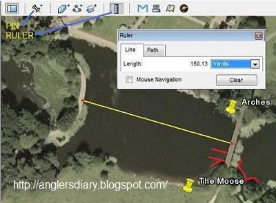
I’ve included a screen print of a section of google earth whilst looking at Cheshire carp water capesthorne hall garden pool to use as my example. Obviously the real map is much bigger and the picture accompanying this piece has been both cropped and reduced to fit this blog page. I’ve marked two particular buttons on the navigation bar, the first is the ‘pin’ and the second is the ruler. You can use the pin to name any particular swims on the lake. If you click it, a pin appears on screen and a box opens. Simply drag and drop the pin to where you want to put it on the map then use the box to give it a name, then click ok. The result will look like the two swims I’ve labelled ‘arches’ and ‘the moose’ on the map.
The ruler is incredibly useful, when you click it, a box appears and I’ve left the box on the map on purpose so you can see it. With the ruler engaged you can measure distances on the map. Simply click where you want to measure from once, then move the target to where you want to measure too then click again. As an example, I’ve measured from the bridge to the side of the pads on the dam wall on capesthorne hall garden pool and the ruler box has given me 150 yards. By using the drop down menu on the ruler box you can have your distance measurements in inches, feet, yards or metres plus a few others!.
The google earth map also shows you which way is north, and you can see the compass in the top right hand corner of the top image in this entry. From knowing which way is north, straight away you can tell which bank a south westerly wind will hit and this kind of information is useful to know when your thinking ahead to actually visiting the lake and locating the carp. The google earth program also allows you to see any visible features like lily pads and you can see areas of pads around the bridge. You can use the ruler to measure the distance from swims to any visible features. As an example, you might use it to measure the distance to an island or to a far bank margin for instance. It’s also accurate, which is more than can be said of local ‘carp folklore’ when it comes to casting distances!.
I usually print my map out once I’ve put pins in for all the swims. With a full A4 size printout of the lake in front of me with swim names pinned on it, I usually then begin adding any distance details by hand, I’ll measure a distance on google earth, then add them to my printout and I do all this from the comfort of my chair and pc. The only thing I ever ask another angler on the lake is the names of the swims. If swims don’t have names or numbers I simply give them my own names, after all, its my work and I’m the one that understands the individual picture I’m trying to build up.
With a nice map and all the distance details I could ever need all documented it’s time for the nitty gritty details that can only be added by spending time at the lake. What details an angler adds to a map are personal. If you like to do lots of marker float work you may wish to add water depths, areas of sand, gravel or silt which can be found by leading about. The sky is the limit really and any information you can add builds up the picture of your chosen venue. Myself, I’ll add depths and bottom make up as and when I fish different swims. I like to add areas that I see carp and I’m quite happy to forsake sitting behind the rods in order to find the carp and observe them. The maps I make for the waters I fish are all marked with the areas I see carp showing regularly. These areas are also broken down, for example, areas I see fish crashing regularly, areas I see fish bubbling or rolling regularly, areas I see carp milling round on the surface, any patrol routes I may observe etc. I’ll also make notes on the conditions in which I see these different kinds of activity. When it comes down to it, a carp anglers own eyes are his very best weapon and time spent looking and watching is never wasted. Information about areas the carp frequent regularly or naturally is worth ten times more than knowing how deep a random spot might be.
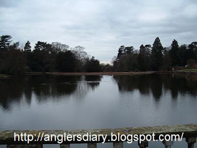
In the google earth shot of the garden pool I’ve used a basic windows program called ’paint’ to add red lines to indicate carp patrol routes. Any capesthorne carp angler who stands on the bridge will notice that the carp use the far two arches to pass from one side of the lake to another. The carp like to keep very close to the rodey bushes and the yew tree before passing through the pads and into the garden pool where they will either go under the rodey bush in the crusoe swim and into the moose, or go straight on into open water. By watching and observing the carp, details like this can be added to a map and the information can be used to good effect when it comes to placing baits.
When it comes to actually fishing, I’ll mark areas I get runs from and I’ll make notes on the conditions and times I catch my fish. All the time I’m fishing a water I’ll add information from each trip and I’ll analyse it and look for emerging patterns in the carps behaviour. One pattern that quite often comes up is carp visiting a certain area of the lake at a certain time of day. When you stumble across areas like this you’re onto a winner and I’ll usually start timing my fishing sessions to drop into these areas a few hours in advance so I can get a quick result.
Given that I like to mark areas that I see fish regularly, I usually start piecing together information on a lake around the late winter time, a few hours digging round looking for the basic water information outlined above is time well spent when its cold and dark outside. Noting specific areas that carp like to frequent is best done in the spring and summer when the carp are more active, lets face it, you’ll see much more in the summer than you will in winter so it pays to approach a new venue at the right time of year. Its groundwork in winter then get out there and find them when its warmer.
The above just about sums up how I approach a new carp water, obviously I’m not going to publish a finished map of a local water, that kind of information is appreciated more when an angler works for it!. I hope you get an idea of how I go about my fishing though. I start and keep a diary. I make a decent map and put as much information on it as I can about the things that are most important to me and that’s the carps location and their typical behaviour in certain areas of the lake. Other anglers may mark depths and bottom make up and I do this myself, but only as and when I fish a swim. The carp themselves will show you the natural areas they prefer. If your prepared to put the time and effort into watching and observing the carp and keep notes of everything you see, eventually you’ll piece things together and crack your chosen venue. I doubt you’ll want to share that hard won information with a forum full of lazy carp anglers looking for shortcuts though!.
Tight Lines
Mark.

Cool!
ReplyDelete